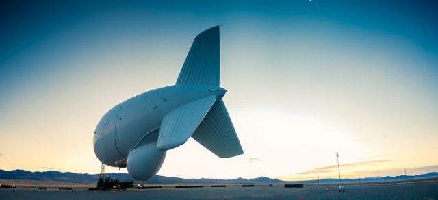
 On Friday, the North American Aerospace Defense Command, NORAD, will launch a giant drone-hunting blimp over Maryland’s Aberdeen Proving Grounds just east of Washington D.C. The system includes a 242-foot balloon (technically called an aerostat because it’s connected to the ground) that can stay up for a month at a time and a radar to detect — among other potential threats— drones.
The danger posed by unmanned drones over Washington, D.C., has been a concern since 9/11. The Federal Aviation Administration and the Transportation Security Administration made it illegal fly model planes within ten miles of Reagan National Airport. But as Zeke Miller reports for TIME, the prospect of actually getting caught flying your drone over Washington, D.C., is “doubtful, unless you upload the video to the Internet, crash spectacularly, or get way too close to a really sensitive area like the White House.”
Case in point is this footage from hobbyist and activist Adam Eidinger, showing a “near miss” over D.C.’s Adams Morgan neighbourhood with a now-missing Chinese-made LotusRC T580 quadcopter. Eidinger told Defense One via Twitter that he “got a warning” and was told to stop flying in Washington, D.C.
Drones near airports are a growing problem. As many as 30,000 drones will crowd America’s skies by 2020, according to University of Texas at Austin engineering professor Todd Humphreys. His numbers are so trusted that they’re what theFAA uses in approximating the future drone population over the United States.
For authorities and national security types, actually finding remote-controlled aircraft is a lot harder than it is for hobbyists to send them up in the sky.
But that’s only one part of the worry. Civilian drones are more vulnerable to hacking and spoofing than those military of the variety since they operate on much more open networks. In June of 2012, Humphreys and several other researchers demonstrated that it was possible to spoof the GPS on a Hornet rotorcraft UAV with little effort. As Humphreys told The Washington Post’s Craig Whitlock, drones with easily hackable navigation represent a “a huge vulnerability.”
You don’t have to be trying to fly your drone into the White House for it to get there.
Why might a blimp (er…aerostat) be the answer? Altitude. The Joint Land Attack Cruise Missile Defense Elevated Netted Sensor System, or JLENS, will fly at 10,000 feet, which allows radar waves to travel farther without running trees, buildings, etc. That enables one JLENS aerostat to effectively cover an enormous area.
A JLENS “orbit” consists of two balloons, one outfitted with a long-band (VHF) surveillance radar that can detect objects in an extremely broad area. The Pentagon will launch the second balloon equipped with a more focused X-Band radar approximately six weeks. The two work together in a tag team. Once controllers find suspicious moving objects with the long-band radar they can zoom in with the X-Band to get better intelligence. The radar may not be effective against extremely small drones, but it could catch the bigger ones, proving some coverage where there is none today.
The JLENS, developed by Raytheon, has been in testing since 2009. It’s been effective in detecting “swarming boats”and other ground or sea-based objects in addition to objects in flight. The system passed its most critical test to date in the fall of 2012 in White Sands, New Mexico, when Raytheon demonstrated that the X-band radar could pick up multiple ballistic missiles.
“JLENS demonstrated its capability against cruise missiles when it enabled Patriot and Standard Missile-6 intercepts of cruise-missile surrogates during separate tests. JLENS also completed two developmental tests and demonstrated its ability to stay aloft for long durations,” the company wrote in a press release.
Supporters of the JLENS programme, such as retired Air Force Col. Gerald M. May, who has worked with NORAD and the United States Space Command, say the JLENS fills a serious gap in the nation’s missile and drone defenses. “The truth is, today the United States has no dedicated defense system to protect the American homeland against cruise missiles and rogue aircraft—except JLENS. Recent approaches to our homeland by Russian and Chinese air and sea-based assets have highlighted our vulnerability to such cruise missile threats. Besides detecting missiles, the mission of JLENSincludes monitoring all air traffic. Rogue aircraft, off-course aircraft and unidentified aircraft will be quickly detected and reported by JLENS to appropriate authorities for action they deem fit,” May told Defense One.
But the system also has its critics, including privacy advocates.
In a 2013 press release, Raytheon announced that the aerostat—outfitted with a Raytheon built MTS-B infrared camera—could monitor human movement from the air. They tested it in a scenario where an individual planted a fake improvised explosive device in a chaotic, smoke-filled setting.
“A recent demonstration proved that operators can observe surface moving targets — including a terrorist role-player planting an improvised explosive device…Despite heavy smoke from recent, naturally-occurring forest fires, an MTS-B electro-optical/infrared (EO/IR) sensor mounted on a JLENSsurveillance aerostat tracked numerous targets with the IRsensor,” the release reads.
Unnerved by the prospect of a military spy balloon floating above major U.S. cities, privacy advocates pounced. The Electronic Privacy Information Center filed a Freedom on Information Act Lawsuit, resulting in the release of more than 145 (highly-redacted) pages on the blimp program. The military has since said that neither of the balloons that will fly in the Maryland region will have the MTS-B camera. The X-band radar that will fly on the second blimp can collect better data on more specific targets, enough to differentiate many by movement type, but it won’t allow operators to see, for instance, through the roof of a vehicle or house.
Importantly, that could limit its ability to detect many of the very small drones that could multiply in the years ahead. The bigger, more detectable drones aren’t necessarily more dangerous.
The military has spent some $2.55 billion in research and development for the JLENS. Raytheon claims that the cost of actually operating an aerostat, versus a fixed-wing aircraft with the same broad surveillance capability (like the Northrup Grumman E-22 Hawkeye or the Boeing E-3 Sentry) is 5-7 times lower for the balloon.
Despite these apparent benefits over fixed-wing surveillance, the JLENS program has never been safe politically. The military in recent years curtailed the scope of the program, from 32 orbits (when the program was originally conceived in 2007) down to two orbits (of two aerostats each), which Raytheon has already built. Will the radar prove effective in catching drones of every conceivable size? This remains to be seen.
The military will conduct tests over Aberdeen Proving Grounds for the next three years. If legal or illegal unmanned areal vehicles proliferate over the nation’s capital in that time, those tests will be thorough.
Source: Defense One
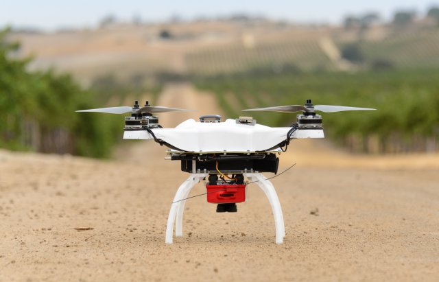 MicaSense, a sensor and information company has raised $2M in Series A funding from Parrot. MicaSense delivers a fully integrated hardware solution for agricultural remote sensing from any unmanned aerial platform, tightly coupled with cloud-based analytics to provide crop health information to growers. The funding will enable MicaSense to expand its engineering and manufacturing capabilities to support a growing network of customers worldwide.
 Philip Blaisdell

